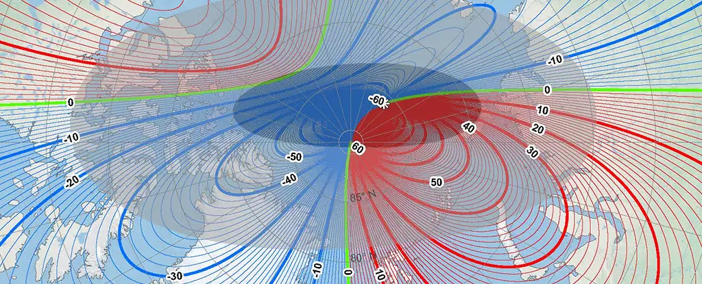
As we navigate through the complexities of our world, the magnetic North Pole’s shifting location plays a critical role in modern navigation systems across various modes of travel. The recent collaborative endeavor by the US National Oceanic and Atmospheric Administration (NOAA) and the British Geological Survey (BGS) has ushered in a new version of the World Magnetic Model (WMM) amidst an extraordinary transformation in the position of the magnetic North Pole. This transition is not merely a geographic curiosity; it holds substantial implications for everything from maritime navigation to aviation, and even funnily, to Santa’s annual journey on Christmas Eve.
The significance of correctly pinpointing the magnetic North cannot be overstated. Unlike the fixed geographical North Pole, which is anchored at the summit of Earth’s rotational axis, the magnetic North Pole is in a state of fluidity, influenced by the dynamic interactions of iron and nickel within the Earth’s core. These subterranean activities are not just abstract geological phenomena; they directly affect navigation technologies that millions rely on daily.
For centuries, the magnetic North Pole has gradually drifted, particularly circling around Canada since the 1500s. Yet, the last couple of decades have seen an accelerated shift towards Siberia, a behavior that global geomagnetic field modeller William Brown from BGS notes is “unprecedented.” Over the past 20 years, the movement has increased in speed dramatically, registering significant fluctuations until a remarkable deceleration was recorded approximately five years ago. The reduction in speed from 50 kilometers to 35 kilometers annually reveals an ongoing, significant transition in Earth’s geomagnetic conditions.
Experts posit that this shift can be attributed to two colossal lobes of magnetic energy located beneath Canada and Siberia. Their influence could mean that the magnetic North Pole experiences sudden and dramatic alterations necessitating immediate adjustments to navigational systems—not just at the typical five-year intervals.
This latest update to the WMM represents not merely a recalibration but a leap in resolution and precision. The introduction of a higher resolution map provides over 10 times more detail than its predecessor. This advanced model offers a spatial precision of about 300 kilometers at the equator compared to the traditional 3,300 kilometers. Such enhancements will profoundly impact navigation efficacy; for instance, a direct flight path from South Africa to the UK, previously calculated using outdated information, could have resulted in being up to 150 kilometers off-course—an unacceptable error margin in today’s world.
The implications of this updated magnetic map resonate especially for industries reliant on accurate navigation, including aviation, shipping, and logistics. Governments and organizations must act promptly to implement these updates to ensure the safety and reliability of their entities. Some may find it comforting to know that these updates will be applied automatically on devices—eliminating the burden on individuals to keep track of such meticulous details.
The journey to this current moment has a rich history. The magnetic North Pole was first identified by Sir James Clark Ross in 1831 within Canada’s vast wilderness. Since that discovery, advancements in technology—ranging from ground measurements collected globally to satellite readings—have allowed researchers to track and monitor these changes with remarkable precision.
Understanding the implications of the repositioning of the magnetic North Pole is an evolving challenge that intersects many disciplines—from earth sciences to technology. The regular updates to the WMM not only enhance our navigational capabilities but also remind us of the ever-changing nature of Earth itself. Just as we prepare for seasonal changes and holidays, we must also remain vigilant and adaptable to the continuous movements beneath our feet, which guide us through our journeys.

